|
|
|
|
 |
|
|
|
|

|
|
Trails
in the
Town
of Oyster Bay, NY |
|
|
|
|
|
|
|
|
 |
 |
BETHPAGE STATE
PARK has hiking and biking trails
(including five miles of the Long Island Greenbelt Trail), playing
fields, tennis courts and cross-county skiing trails. Best best
known for its five world-class golf courses, but visitors flock to
the park to use its picnic facilities, bridle paths.  |
| More info/photos |
|
|
|
|
|
|
|
|
 |
|
Bethpage
BETHPAGE MOUNTAIN BIKE TRAIL has four miles
long from Bethpage State Park gatehouse, white triangles mark the
off-road, marked loop trail..More
|
|
Map
it |
|
|
|
|
|
|
|
 |
|
N
Massapequa
MASSAPEQUA PRESERVE is a long thin
Preserve that runs from Merrick Road to Linden Blvd. on the Northern
end. It is a wooded area that surrounds a stream. There are two
paths. One path is the Greenbelt Trail located through the woodland.
The other is along the bicycle path which follows the stream and
around the ponds. |
| More info/photos |
map
it |
|
|
|
|
|
 |
|
Syosset
MUTTONTOWN PRESERVE
has a marked self-guiding trail that
surrounds one of the old mansions, Chelsea, which is now used for
selected cultural exhibitions and affairs. This 550-acre preserve
combines the assets of a number of old North Shore estates to
provide a quiet, rural, and startlingly extensive area for woodland
walks. More info/photos
|
|
map
it |
|
|
|
|
|
|
|
|
|
 |
 |
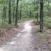
Woodbury
TRAIL VIEW STATE PARK
is a 400-acre, 7.4-mile linear park that serves as a link along the Nassau/Suffolk Greenbelt Trail that extends from Cold Spring Harbor State Park on the north shore of Suffolk County to Bethpage State Park, and eventually to the south shore of Nassau County.
More info/photos
|
|
map
it |
|
|
|
|
|
|
|
|
|
|
|
|
|
|
|
|
|
|
|
|